Services

Boundary Survey
A Boundary Survey determines the exact property lines and corners of a parcel of land. This survey is essential for property transactions, resolving boundary disputes, obtaining building permits, and ensuring compliance with zoning and land use regulations. It involves researching historical records, measuring the land using professional surveying equipment, and preparing a certified plat or map showing property boundaries.

Boundary Survey with Elevations
A Boundary Survey with Elevations includes the precise location of property lines along with elevation data. This type of survey is useful for land development, floodplain analysis, and grading plans. It provides essential information for engineers, architects, and builders who need to understand both boundary limits and the vertical aspects of the land.

Construction Stake Out
Construction Stake Out, also known as Construction Layout, ensures that structures are built in the correct location according to the project’s design plans. Surveyors place stakes or markers on-site to indicate where foundations, roads, utilities, and other elements should be constructed. This service is crucial for accuracy in construction projects and helps prevent costly errors or rework.

Elevation Certificates
An Elevation Certificate provides critical elevation data for properties in flood-prone areas. It is used to determine flood insurance rates, ensure compliance with FEMA and local floodplain management regulations, and support applications for Letters of Map Amendment (LOMA). The certificate includes information about the building’s elevation relative to the Base Flood Elevation (BFE), helping property owners understand their flood risk.
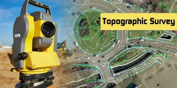
Topographic Surveys
A Topographic Survey maps the natural and man-made features of a property, including contours, elevations, trees, buildings, roads, and utilities. This type of survey is essential for land development, engineering design, and environmental assessments. It provides a detailed representation of the terrain, helping professionals plan site improvements, drainage systems, and construction projects effectively.
"The precision and professionalism of this surveying team exceeded my expectations. Highly recommend!"

"The precision and professionalism of this surveying team exceeded my expectations. Highly recommend!"

"The precision and professionalism of this surveying team exceeded my expectations. Highly recommend!"

Clients and testimonials
Use this section to enhance your company's reputation in the surveying industry.